
Hiking Potato Chip Rock and Mount Woodson
Last Updated on August 26, 2024 by Polly Dimitrova
After coming back from Death Valley National Park, the hiking adventures around San Diego, CA continue. Being completely transparent, the weekend after coming back from Death Valley, we were so adventured out that we did not plan anything adventurous and took a 2-mile walk in a local park. Nothing spectacular, but it got the mileage in and got us out into the fresh air of nature. The following week, however, we’re back and ready for something fun, challenging, and spectacular! As one of the most popular hiking trails in the area, it was only natural that we had to make our way up to the local favorite, Potato Chip Rock!
While many visit with the simple intention of a photo op with one of the most iconic tourist attractions in San Diego, we were tempted by the length and difficulty of this hiking trail. Yes, starting from Lake Poway, it is 8 miles round trip and can take up to 5 hours! It is absolutely worth it with incredible scenery, views out to the ocean, and the Potato Chip Rock at the end is only a small fraction of the adventure!
About Potato Chip Rock
First thing that we need to make clear is that the Potato Chip Rock is located just 100 feet below the 3000 foot tall Mount Woodson. And while the Potato Chip Rock might have gained its popularity recently through people sharing their photos on social media, the area keeps thousands of years of rich history and heritage! Named the “Mountain of the Moonlit Rocks”, Mount Woodson was regarded as a place of significant power and energy by the Kumeyaay tribe. Nowadays, the Potato Chip Rock has become a well-known nickname for the hike, however, its actual name is Mt Woodson Trail! It is always good to know where you are going, right?!
There are a number of different options for hiking Mt Woodson and the Potato Chip Rock. One of the most popular and surprisingly easiest trails starts from Lake Poway with a western approach to the summit. This is the one we opted for as well, so keep in mind that the hiking guide listed below covers this particular route.
Getting to Mount Woodson Trailhead
As previously mentioned, we chose the trail starting from Lake Poway Recreational Area situated in its namesake town just north of San Diego. Coming from the North or South, take highway I-15 before following Rancho Bernardo Road. As you continue East, the road transitions into Espola Road. Follow along as the road curves to the right. After about 1.5 miles, you will need to take a left onto Lake Poway Road. Keep driving until you reach the massive parking lot part of Lake Poway Park.
Entrance Fee and Opening Hours at Lake Poway Park
Keep in mind that if you are a non-resident of Poway, you would have to pay a parking fee of $10 if visiting on a weekend. It is notable that active Military with a valid ID also gets free parking. Opening hours are from 6 AM to sunset everyday, but the concession area is only operational Wednesday through Sunday.
When to Visit Mt Woodson Trail
San Diego County locals flock to the Potato Chip Rock every weekend, so you want to start as early as possible. At the narrow sections of the trail, you are forced to stop to allow for people coming from the other direction to pass. There is also a minimal amount of shade along the way, so it is advised to avoid the hot summer months!
Hiking Mount Woodson and Potato Chip Rock via Lake Poway
Distance: 8 miles round trip
Duration: 4 – 5 hours round trip with breaks
Elevation Gain: 2000 ft
Entrance: $10 parking on weekends, Free for Military with ID
Dogs: Allowed on leash
Difficulty: Moderate – Difficult
Do not Forget: WATER! (More on this later)
Starting Point: 33.006589,-117.013904
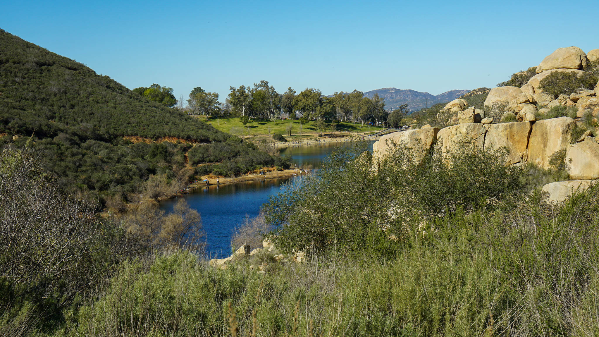
Once you have found a spot to park, head towards Lake Poway’s boat dock. A large board sign and a map mark the beginning of the Lake Poway Trail that connects to the Mt Woodson Trail. Yes, it is confusing and we had some issues with the trail markers later, but fear not – with a bit of trail sense and reading, it will take you to the top! Follow the paved path for a few steps until you notice the small dirt path to the right. This trail will take you above the main paved trail and up towards your mountainous adventure.
In about 0.2 miles, you will reach the first intersection. Follow the “Lake Poway Trail” sign pointing to the left. An initial steady incline hints at what you should be prepared for. Lake Poway lies to your left as you make your way up the hill. Keeping a good steady pace here (one of the most essential hiking tips for beginners) is a good idea as the actual incline follows shortly. The beautiful views of the crystal clear blue waters of the lake get even more spectacular the higher you go. Taking a quick glimpse and soaking in the scenery can be a great motivator (and excuse!) for when you need to catch your breath.
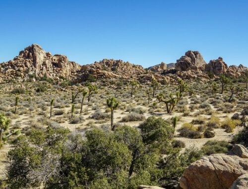
Take the gentle descent down the hill and get ready because once at the base, you will see the official start of Mount Woodson Trail. A sign indicates that Mt Woodson Summit is another 2.9 miles away. Say goodbye to the lake as it will soon hide away behind the hills and keep your feet moving forward – This is where the real climb begins! A wide dirt path will lead your way for the next mile. Keep your eyes open for the blooming trees on each side of the path. Depending which time of year you are visiting, you can see purple lavender, white ceanothus, and yellow wildflowers amongst additional beauties strewn across the landscape.
Make sure to stay on the main trail. You might notice a small pathway to the left, which eventually connects to the main trail, however, it is significantly steeper and narrower. About a third of the way into the hike, you will reach a wide open area with a few benches. This is the perfect spot to take a break and enjoy the views because the most challenging section is yet to come! The more adventurous can climb the miniature, adjacent peak for even better views and the opportunity to look down upon the other hikers for a spare moment!


After a well-deserved break, continue for a few more minutes before reaching another intersection. There is a trail mark pointing to the left and indicating another 1.9 miles to Mt Woodson Summit. The path slowly starts to narrow at this point. Rocks have been used to create stairs in order to make this next section a bit more manageable. Still, you have entered the most strenuous yet interesting portion of the trail.
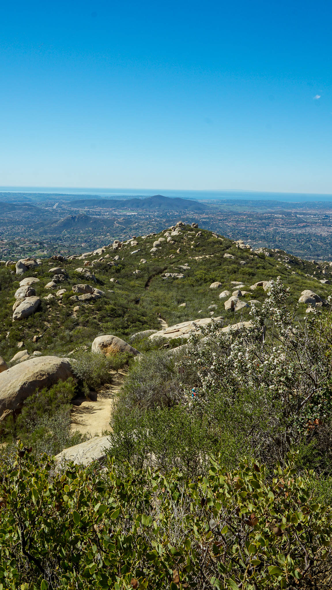
A very rocky, strenuous climb follows for one mile. The path gets very narrow and quite congested. Uphill hikers normally have the right of way, but we noticed that many were not aware of the trail etiquette so we had to keep stopping for downhill hikers. Despite our heavy breathing and the continuous uphill we really enjoyed this portion of the hike. The path winds in between a field of massive smooth boulders. Finding interesting shapes in the rocks and peaking at the scenery beneath us kept us occupied while we quickly made our way to the ridge.e quickly made it all the way to the ridge.
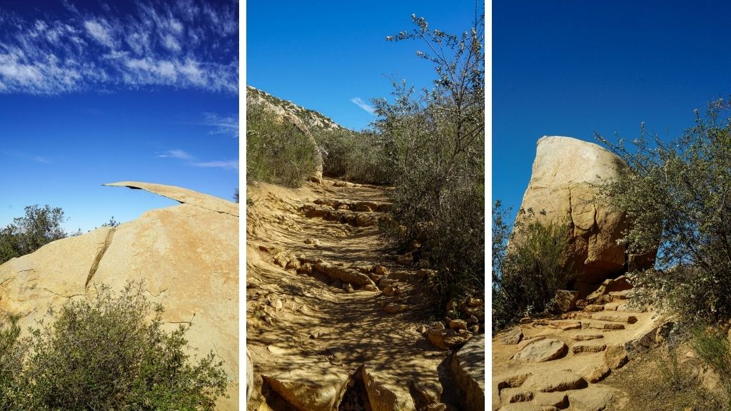
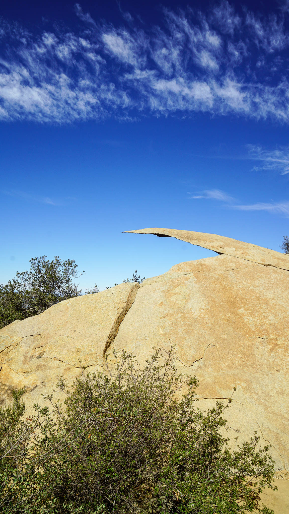
The last section of the trail follows the ridgeline and is a lot easier. I would like to say that the trail is almost flat for the last mile, however, realistically the climb continues – it is just a lot less substantial. Soon after, as you peek behind one of the boulders, you will see the radio towers rising high atop Mount Woodson. Clusters of boulders are sporadically scattered down the hills. As you come up the final gentle slope and ridgeline, and around a few granite boulders, you will see large groups of people gathered beneath the summit. After proudly enjoying that you have finally made it, you can catch your first glimpse of Potato Chip Rock suspended miraculously over the edge of the vista before you. A few feet are keeping you away from the final destination, so keep on going!
Once you reach Potato Chip Rock you would immediately notice the massive line of people waiting to climb on top of it. If you want that photo, you would want to join the queue as soon as possible. Be prepared for the wait, because it takes quite a while. Besides everyone taking at least a few minutes for their photoshoot, climbing on top of the thin rock is not the easiest. There are two boulders right next to each other with a small crack in between. The furthest one is Potato Chip Rock, but you still have to conquer the other one first.


The first thing we noticed upon reaching this gathering point was the massive line of people waiting for their photo op on top of Potato Chip Rock. If you want that photo, be sure to join the queue as soon as possible. Be prepared for the wait because the line moves slowly as everyone gingerly climbs onto the rock, strikes multiple poses and then crawls off it. Besides everyone taking at least a few minutes for their photoshoot, climbing on top of the thin rock is not the easiest. There are two boulders right next to each other with a small crack in between.
Though I may sound disenchanted about it, the view is spectacular and the rock seems to completely defy the rules of nature. A photo is almost an obligation except for the few, like myself and my husband, that detest crowds. We were completely content sitting in the shade after the arduous hike and enjoying our well earned sandwiches we made the night before!
After cooling off, we found another nice boulder to sit on and soak in the beautiful scenery. We were treated to a very beautiful, sunny day and the visibility was excellent. We could even catch a glimpse of the ocean sitting on the distant horizon.
After taking the necessary break and refuelling with some sandwiches and snacks, we took the same way back down. Going downhill was much easier as it only took us about an hour. While we thoroughly enjoyed the effort, the views, and the day as a whole, my husband and I both agreed that it was a bit too crowded for our liking. We definitely loved the challenge and how unique the landscape was with the various boulders lining the path, however, the crowds did not allow us to fully immerse ourselves into the surroundings. We agreed that we would love to come back and do this hike on a weekday and start earlier so we could beat the heat and avoid the crowds!
Tips for Visiting Potato Chip Rock
- Bring a lot of water for this hike! We both drank over 1 liter just on the way up. We had a total of 3.5 liters for both of us and it was just right. We saw a lot of people heading up in the high noon heat with just a small 500 ml / 16 oz water bottle – do not make this mistake! Bring at least 2 liters of water per person!
- Bring snacks and food! We did this hike with a few friends and no one else had thought of bringing food. Once you are at the top, you will thank yourself for bringing sandwiches and snacks!
- This hike is no joke if you do not have experience hiking. We ranked it moderate to strenuous and we consider ourselves fairly experienced hikers. Be prepared for a continuous uphill for about 3.5 miles.
- Besides the distance, you also have to be realistic with how much time is needed for this hike. Gaining 2000 feet of elevation takes a considerable amount of time. Plan approximately 4 – 5 hours for this hike, including the breaks. If you are planning on taking a photo with the Potato Chip Rock, add at least another 40 minutes.
- The trail is fairly well marked, so there is no large chance of getting lost. The trail marks, however, did not seem to show the correct mileage and it could be a bit misleading. In the end we decided Lake Poway and Mount Woodson are different trails that follow each other and the mileages don’t aggregate between their respective trail markers.
- Wearing good hiking shoes on this hike is absolutely essential. Keep the Chucks, Vans, and flip flops at home and opt in for running shoes, trainers, or hiking boots if available. The duration with the elevation gain will definitely make your feet tired.
- Try doing this hike on a weekday if at all possible. During the weekend, it gets far too crowded and it takes a little bit away from the experience!
We have always enjoyed being active and spending time in nature. With various hiking trails, we are getting to experience more of the area we recently moved to – San Diego County. Be sure to come back next week for another hiking adventure!


2 Comments
Josy A
Everything about this sounds fun (as long as you have plenty of water…) apart from the news you have to queue at the top for a photo. That always makes me a bit less keen while you want for the folks that need a full photo shoot. I looove the views with all those other potato-like rock shapes.
Polly Dimitrova
Yes, it was a bit too crowded for our liking as well. We absolutely would have not waited in line just for that one photo 😀
But, visiting on a week day I am sure is much better!